A 5.6 – magnitude earthquake struck Indonesia on Monday, 21, 2022, killing 162 people in Cianjur in West Java. According to the USGS PAGER approximately 242, 000 people experienced very strong while up to 978,000 experienced strong shakings. According to ReliefWeb, about 58 400 were displaced, and over one thousand injuries were reported by Thursday, 24 November 2022. The earthquake originated from a depth of 10 Km.
Two modes of ground failures estimated by USGS: Landslide and Liquefaction. Although little or no landslides and liquefaction hazards have been reported, these hazards could have occurred in highly susceptible areas. For example, West Java is prone to landslides, and hundreds of buildings were destroyed or damaged.
Earthquake frequency in Indonesia
This is not the first time that similar high-magnitude earthquakes have hit Indonesia. For example, on 12 September 2022, a 6.2 magnitude earthquake was recorded in West Sumatra, originating from 11 Km depth. The epicentre of this earthquake was placed at the sea, but no tsunami alert was expected. Indonesia records earthquakes of various magnitudes every year, often resulting in the loss of lives and property.
The data presented by the USGS indicate that, in 2021, a total of 1730 earthquakes above the magnitude of 4.0 were recorded. Of these, 121 events recorded a magnitude between 5.0 and 5.9 and 11 were above 6.0. In 2020, however, relatively fewer earthquakes were recorded (total = 1692) above 4.0 magnitude, where 113 were between 5,0 and 5.9 and 10 were above 6.0. By October this year (2022), a total of 809 earthquakes were reported by USGS above 4.0 magnitude.
The largest of these events was the 26 December 2004, with a magnitude of 9.1 recorded at Sumatra-Andaman. This earthquake occurred along subduction zones where the Indian oceanic plate is subducting beneath the Burma microplate. Read more about the 2004 Sumatra-Andaman earthquake and its Tsunami effects. A year later, on 28 March 2005, an 8.6 – magnitude earthquake occurred in northern Sumatra, causing major Tsunamis.
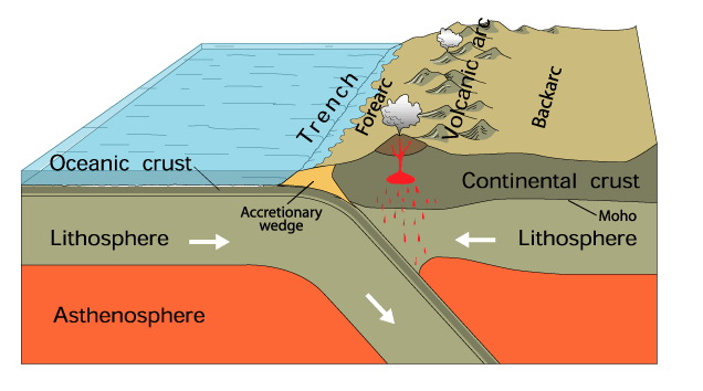
USGS: General diagram of an oceanic subduction zone. Sumatra and the Andaman Islands are part of an island arc.
Earthquake effects in Indonesia
Damage from landslides, tsunamis, and ground raptures are only a few of the many effects of earthquakes. The most significant after-earthquake secondary consequence is flames, as well. For example, the 2004 Sumatra-Andaman earthquake in Indonesia registered a magnitude of 9.1 that caused s There over 225,000 casualties.
Indonesia is generally prone to so-called Tsunami earthquakes. The phrase “tsunami earthquake” describes unusual earthquakes in which the tsunami is larger than would be predicted based on the earthquake’s magnitude. These earthquakes frequently cause damage to the interplate thrust just above the trench where it meets the sea floor.
Why is Indonesia prone to earthquakes?
The USGS identifies Indonesia as one of the most seismically active countries in the world. It is situated within the Pacific Ring of Fire, the largest volcanic and seismic zone in the world and the source of 81 % of known earthquakes. In addition, Indonesia is in a junction of three major tectonic plates: the Eurasian, Indo-Australian and pacific. Other smaller but tectonically significant plates include the Philippine Sea plate and the Caroline Plates.
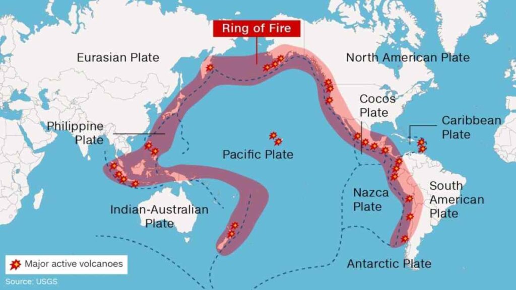
The Ring of Fire comprises approximately 25 000 miles (40, 233.6 km) of a chain of active volcanoes, making it a seismically active region in the Pacific Ocean. About nine (9) major plates meet and encircle the large Pacific Plate at the Pacific Ring of Fire, also known as the Circum-Pacific Belt, including; Cocos, Caribbean, Philippine, Nazca, Antarctic, North America, Juan de Fuca, Australian, and the Eurasian. It is one of the most interesting regions that geologists love to study in plate tectonics.
Plate tectonics implies that the plates are constantly sliding past, moving above, colliding into and moving below each other. The results of these movements are the formation of deep ocean trenches, earthquake epicentres and volcanic eruptions at the boundaries where these plates meet (fault lines).
Would you like to know if there is an earthquake near you?

The USGS ShakeMap shows daily and hourly earthquake events globally. The map captures any earthquake above 2.5 Ritcher’s scale magnitude and is produced in conjunction with the regional seismic networks.
Written by JFT; November 2022