
Geoscience innovation in Africa is becoming increasingly important as the continent faces growing environmental, climate, and urbanization challenges. Across Africa, scientific research and technological innovation are transforming how governments, researchers, and communities understand water systems, environmental risks, climate change, and natural resources.
As climate pressures intensify, the demand for accurate environmental data and sustainable planning is growing rapidly. Floods, droughts, groundwater depletion, pollution, and land degradation are no longer isolated environmental concerns. They are now directly connected to urban resilience, food security, infrastructure development, disaster preparedness, and economic sustainability.
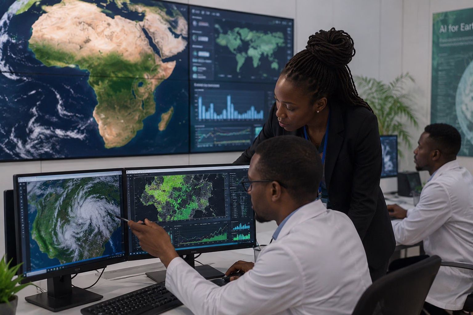
Modern geoscience technologies such as Geographic Information Systems (GIS), satellite monitoring, artificial intelligence, groundwater mapping, and environmental monitoring are helping African countries improve decision-making and strengthen resilience planning. These innovations are changing how climate risks are predicted, how disasters are managed, and how environmental systems are monitored across the continent.
The future of geoscience innovation in Africa will not only shape scientific research, but also influence how African societies prepare for climate uncertainty and sustainable development.
Why Geoscience Innovation in Africa Matters More Than Ever
Africa is one of the regions most vulnerable to climate change despite contributing relatively little to global carbon emissions. Rising temperatures, unpredictable rainfall, floods, droughts, and environmental degradation are increasing pressure on ecosystems and urban systems across the continent.
At the same time, Africa’s population continues to grow rapidly. According to the African Development Bank, the continent’s urban population is expected to exceed 1.4 billion people by 2050. This growth increases demand for water, infrastructure, environmental management, and climate-resilient planning.
This is where geoscience innovation in Africa becomes critically important. Scientific tools and environmental technologies are helping governments and researchers:
- monitor environmental change
- predict climate risks
- improve groundwater management
- strengthen disaster preparedness
- support sustainable urban planning
- protect natural resources
Without strong geoscience systems, many African countries may struggle to respond effectively to future environmental challenges.
GIS Technology Is Transforming Environmental Planning in Africa
Geographic Information Systems (GIS) have become one of the most powerful tools in modern environmental science. GIS technology allows researchers and planners to collect, analyze, and visualize spatial data for better decision-making.
Across Africa, GIS is increasingly being used for:
- flood risk mapping
- groundwater assessment
- urban planning
- land use monitoring
- environmental conservation
- infrastructure development
In Kenya, GIS technologies are helping environmental experts monitor urban expansion, flood-prone zones, and water distribution systems in rapidly growing cities such as Nairobi. GIS mapping is also being used in agriculture to improve land management and climate adaptation planning.
The growing use of GIS demonstrates how geoscience innovation in Africa is improving environmental management and scientific research across multiple sectors.
Satellite Monitoring Is Strengthening Climate and Environmental Research
Satellite technology is playing an increasingly important role in environmental monitoring across Africa. Satellites provide large-scale environmental data that helps researchers track climate trends, vegetation changes, water systems, land degradation, and disaster risks in real time.
Countries and organizations across Africa now use satellite monitoring to:
- detect drought conditions
- monitor flood risks
- track deforestation
- assess water availability
- analyze climate variability
In East Africa, satellite data has become essential for monitoring drought conditions affecting millions of people. Climate scientists use remote sensing technology to identify areas experiencing declining rainfall, vegetation stress, and water shortages before crises become severe.
Satellite monitoring is therefore becoming one of the most valuable components of geoscience innovation in Africa because it improves early warning systems and strengthens climate resilience planning.
Artificial Intelligence Is Expanding Environmental Science Capabilities
Artificial intelligence (AI) is beginning to transform environmental science and geoscience research across the world, including in Africa. AI systems can analyze massive amounts of environmental data much faster than traditional methods, helping scientists identify patterns and predict risks more efficiently.
AI is increasingly being used for:
- climate prediction
- flood forecasting
- drought analysis
- environmental monitoring
- groundwater modeling
- disaster risk assessment
Researchers are now combining AI with satellite data and GIS systems to improve climate forecasting and environmental planning across vulnerable regions.
For example, AI-assisted climate models can help predict areas likely to experience severe flooding or drought, allowing governments and communities to prepare earlier.
As environmental pressures continue to grow, AI will likely become a major driver of future geoscience innovation in Africa.
Groundwater Mapping Is Becoming Essential for Water Security
Groundwater mapping is becoming increasingly important as African cities and rural communities face growing water insecurity. In many regions, groundwater acts as a critical backup resource during drought periods and water shortages.
Hydrogeologists use advanced geoscience technologies to identify underground aquifers, assess water quality, and monitor groundwater sustainability. GIS systems, remote sensing technologies, and digital groundwater models are helping researchers better understand underground water systems across the continent.
In Kenya, groundwater mapping is increasingly important in counties experiencing rapid urban growth and water demand pressure. Areas around Nairobi, Kajiado, and Kiambu continue to rely heavily on boreholes and underground water systems during periods of water rationing.
The future of sustainable water access may depend heavily on how effectively geoscience innovation in Africa supports groundwater management and protection.
Learn more in our article on groundwater in Africa and sustainable water systems.
Climate Prediction and Drought Analysis Are Improving Preparedness
Climate prediction systems are becoming increasingly important as Africa experiences more frequent climate-related disasters. Accurate climate forecasting allows governments, farmers, researchers, and disaster response agencies to prepare for changing environmental conditions.
Advanced climate models now help scientists:
- forecast rainfall patterns
- monitor heatwaves
- analyze drought severity
- assess flood risks
- improve food security planning
In the Horn of Africa, repeated drought events have affected millions of people over recent years. Climate monitoring systems are helping humanitarian organizations identify vulnerable areas earlier and improve response planning.
Improved forecasting demonstrates how geoscience innovation in Africa is strengthening resilience and reducing disaster vulnerability.
The future of climate resilience in Africa will depend not only on infrastructure and policy, but also on how effectively scientific innovation can transform environmental data into practical action.
Flood Monitoring Is Becoming Critical for Urban Resilience
Flooding is becoming one of the most destructive climate-related challenges affecting African cities. Urban flooding damages infrastructure, contaminates water systems, disrupts transportation, and increases public health risks.
Flood monitoring systems now combine:
- GIS technology
- satellite monitoring
- rainfall analysis
- hydrological modeling
- real-time environmental data
In cities such as Lagos and Nairobi, flood-prone areas are increasingly being mapped using geospatial technologies to improve urban planning and disaster preparedness.
As urban populations continue to grow, flood monitoring will remain one of the most important areas of geoscience innovation in Africa.
Environmental Monitoring Is Supporting Sustainable Development
Environmental monitoring systems help scientists and policymakers track changes in ecosystems, pollution levels, water quality, and land degradation over time.
Across Africa, environmental monitoring is increasingly important for:
- pollution management
- water quality assessment
- ecosystem protection
- climate adaptation
- sustainable urban development
Industrial pollution, poor waste management, and rapid urbanization continue to threaten environmental sustainability in many African cities. Monitoring systems help researchers identify environmental risks earlier and improve long-term planning.
Organizations such as the UN Environment Programme continue to support environmental sustainability and climate resilience initiatives globally.
The expansion of environmental monitoring technologies demonstrates how geoscience innovation in Africa is increasingly connected to sustainable development goals.
Urban Planning and Disaster Preparedness Are Entering a New Era
Modern geoscience technologies are transforming how African cities prepare for environmental risks. Urban planners increasingly rely on climate data, flood maps, satellite imagery, and environmental monitoring systems to guide infrastructure development and resilience planning.
Disaster preparedness now depends heavily on:
- accurate environmental data
- early warning systems
- climate forecasting
- hazard mapping
- risk analysis technologies
Cities that integrate scientific data into planning systems are often better prepared to manage climate risks and reduce environmental vulnerability.
This means that geoscience innovation in Africa is no longer limited to scientific research alone. It is becoming a central part of urban resilience, economic planning, and sustainable development strategies.
Geoscience innovation in Africa is also playing a critical role in climate change monitoring and adaptation. Scientists are using advanced geoscience innovation techniques in Africa to study drought patterns, rainfall variability, and rising sea levels. These innovations help governments and organizations design better climate resilience strategies tailored to African environments.
The Future of Geoscience Innovation in Africa
The future of geoscience innovation in Africa will likely shape how the continent responds to climate change, environmental pressure, urban growth, and resource management challenges over the coming decades.
GIS systems, satellite monitoring, AI, climate forecasting, groundwater mapping, and environmental monitoring are already transforming scientific research and resilience planning across Africa. As these technologies continue to evolve, they will become even more important for supporting sustainable cities, protecting ecosystems, and improving disaster preparedness.
Africa’s future resilience will depend not only on access to technology, but also on investment in scientific research, education, data systems, and skilled professionals capable of translating environmental knowledge into practical solutions.
Geoscience is therefore becoming far more than an academic discipline. It is emerging as one of the most important foundations for climate resilience and sustainable development across the continent.