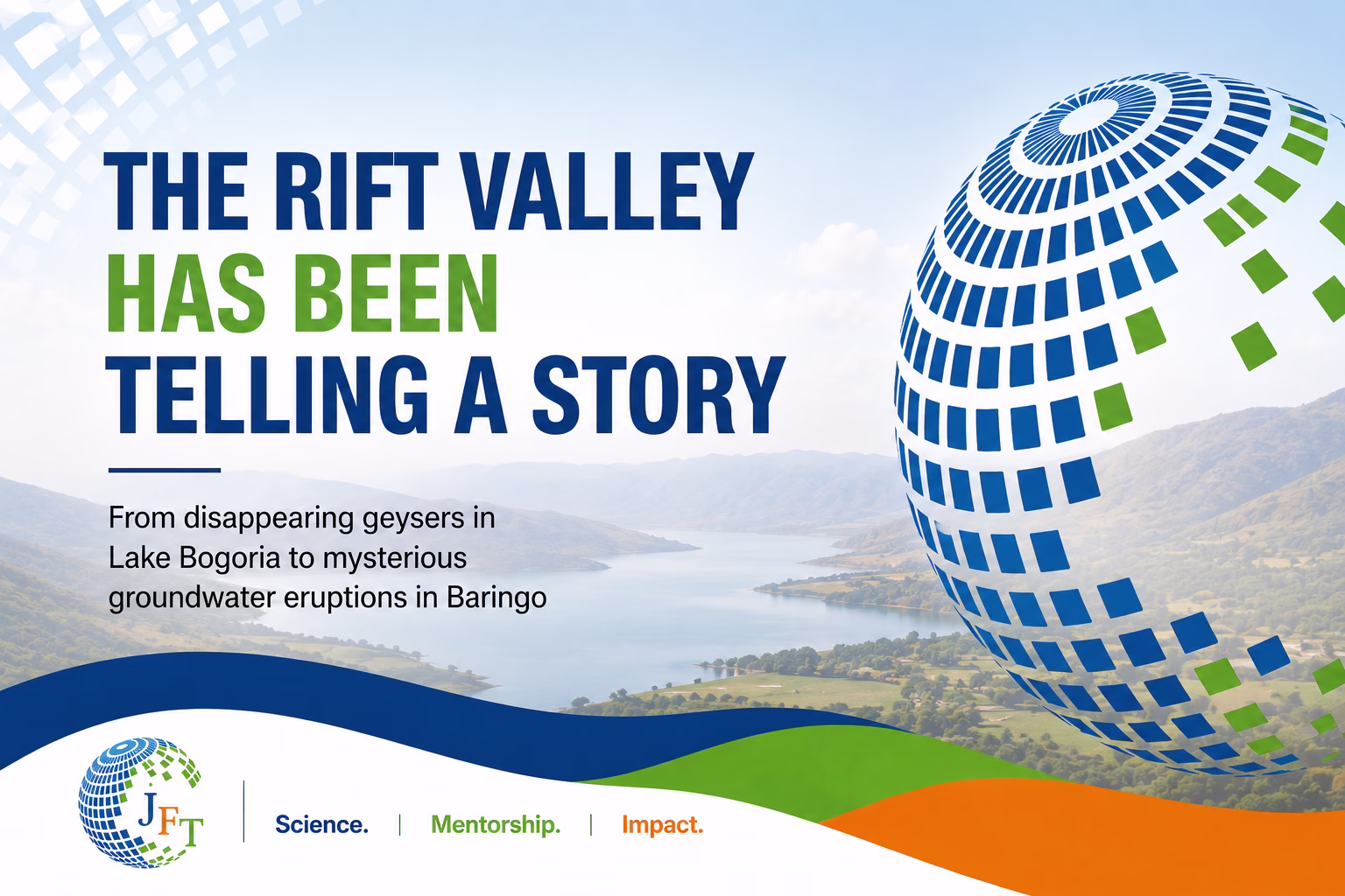
The Rift Valley Has Been Telling a Story: Olkokwee groundwater eruption
For years, the Great Rift Valley of Kenya has been quietly changing.
Its lakes have expanded. Roads have disappeared beneath water. Communities have been displaced. Wetlands have emerged where dry land once existed. In some places, groundwater has started appearing unexpectedly from beneath the earth itself.
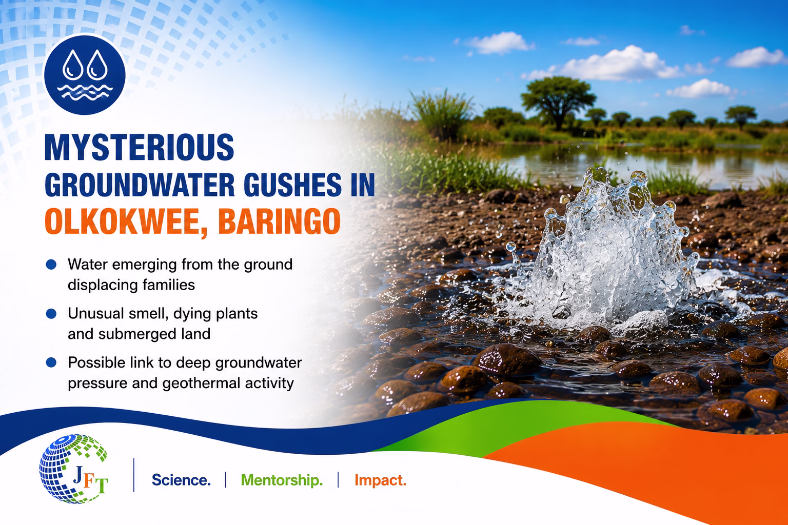
Now, the mysterious Olkokwee groundwater eruption reported in Olkokwee, Baringo — where more than 60 families have reportedly been displaced accrding to the local residents and hundreds of acres submerged — may be the latest chapter in a much larger geological and hydrological story unfolding across the Rift Valley.
This is not simply about flooding.
The Rift Valley itself appears to be speaking through its lakes, springs, geothermal systems, underground aquifers, and shifting landscapes.
A Valley Built by Earth Forces: What is a Rift Valley?
A rift valley is a long depression in the Earth’s surface formed when tectonic forces slowly pull the crust apart. As the crust stretches, it fractures and sinks between parallel fault lines, creating deep valleys and highly active geological environments.
Rift valleys are found in several parts of the world, including:
The East African Rift System
The Jordan Rift Valley in the Middle East
The Baikal Rift Zone in Russia
The Rio Grande Rift in the United States
Parts of Iceland, where tectonic plates are actively separating
The East African Rift System is among the most dramatic and scientifically important rift systems on Earth. It stretches from the Red Sea and the Afar region of Ethiopia, through Kenya and Tanzania, and continues southward toward Mozambique.
In Kenya, the Rift Valley cuts across the country from north to south, shaping some of the nation’s most iconic landscapes — escarpments, volcanic mountains, geothermal fields, lakes, and underground aquifer systems.
The Rift Valley is defined by powerful geological and hydrological features, including:
1. Deep Underground Volcanic Groundwater Systems
Large underground reservoirs store water within fractured volcanic rocks. Some of these aquifers are extremely deep and may interact with geothermal heat from below the Earth’s surface.
2. Fault and Fracture Systems
The Earth’s crust in the Rift Valley is heavily cracked by tectonic activity. These fractures act as underground pathways that allow groundwater, gases, and heat to move through the subsurface.
3. Hot Springs and Geysers
Hot groundwater rises naturally to the surface where underground water interacts with geothermal heat. In some locations, pressure builds up enough to create erupting geysers.
4. Geothermal Activity
The Rift Valley is one of Africa’s most active geothermal regions. Heat from deep underground drives steam systems, hot springs, and geothermal energy development.
5. Saline and Freshwater Lakes
The valley hosts both freshwater and highly saline lakes, many of which are hydrologically connected to groundwater systems beneath the surface.
6. Confined Aquifers Under Pressure
Some groundwater systems are trapped beneath impermeable rock layers. When pressure builds, water may naturally rise or erupt through fractures without pumping.
Beneath the beautiful landscapes lies a dynamic underground world where groundwater, heat, gases, rocks, and tectonic pressure continuously interact.
For decades, many of these processes remained largely invisible.
But recently, the Rift Valley has been revealing signs that something deeper may be changing.
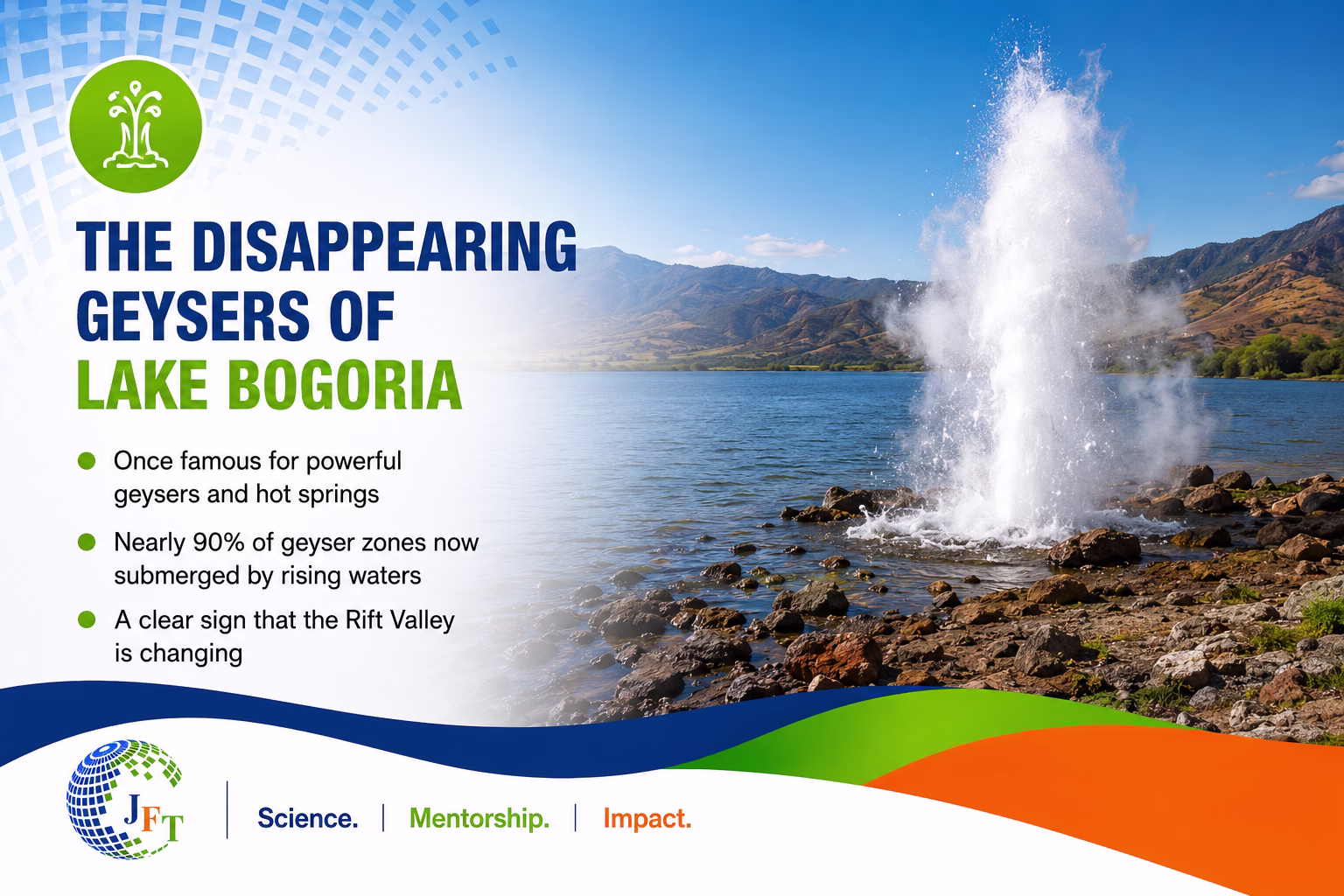
The Disappearing Geysers of Lake Bogoria
From Disappearing Geysers in Lake Bogoria to Mysterious Groundwater Eruptions in Baringo
Few places symbolize the geological power of the Rift Valley more dramatically than Lake Bogoria.
The lake has long been famous for:
Bubbling hot springs
Steaming geothermal vents
Powerful geysers
Vast flamingo populations
Highly saline waters
Geologically, a geyserforms when underground water is heated by hot rocks or magma beneath the Earth’s surface. Pressure builds within underground chambers until the superheated water violently erupts upward through narrow openings.
Lake Bogoria has historically hosted one of the richest geothermal landscapes in Africa. Scientific studies and surveys have documented more than 200 hot and warm springs around the lake, many directly connected to geothermal activity beneath the Rift Valley floor.
For decades, the geysers of Bogoria attracted tourists, researchers, photographers, and local visitors fascinated by the dramatic interaction between fire, heat, water, and geology.
But over recent years, local communities and visitors began noticing something unusual.
Many of the famous geysers started disappearing beneath rising lake waters.
Beginning around 2019–2020, rapidly rising lake levels submerged large sections of the geothermal zones surrounding the lake. Reports from local authorities and environmental observations suggested that a significant proportion of the previously visible geyser fields had become inundated.
Areas once known for boiling geothermal activity became submerged beneath expanding waters.
Roads collapsed. Tourist pathways disappeared. Lodges and viewing areas were damaged. Wetlands shifted location. Flamingo feeding grounds changed. Entire ecological zones were transformed.
Importantly, the geysers themselves may not have “died.”
Instead, the lake changed around them.
The geothermal system likely still exists beneath the water, but the surface expression of that system became hidden as hydrological conditions changed.
It was as though the Rift Valley was reorganizing its own geothermal and groundwater systems.
Rising Rift Valley Lakes: A Regional Pattern
The rising lakes phenomenon is not confined to Lake Bogoria alone.
Across Kenya’s Rift Valley, several lakes have expanded dramatically over the past decade, including:
Lake Baringo
Lake Nakuru
Lake Naivasha
Lake Turkana
Lake Elementaita
Entire communities have been displaced. Schools, churches, roads, farms, and tourism facilities have been submerged.
In some regions, shorelines moved hundreds of meters inland. Infrastructure built decades earlier suddenly found itself underwater.
Similar patterns have also been observed in parts of Ethiopia and other Rift-related basins in Eastern Africa, where changing rainfall patterns and hydrological shifts have affected lake levels and wetland systems.
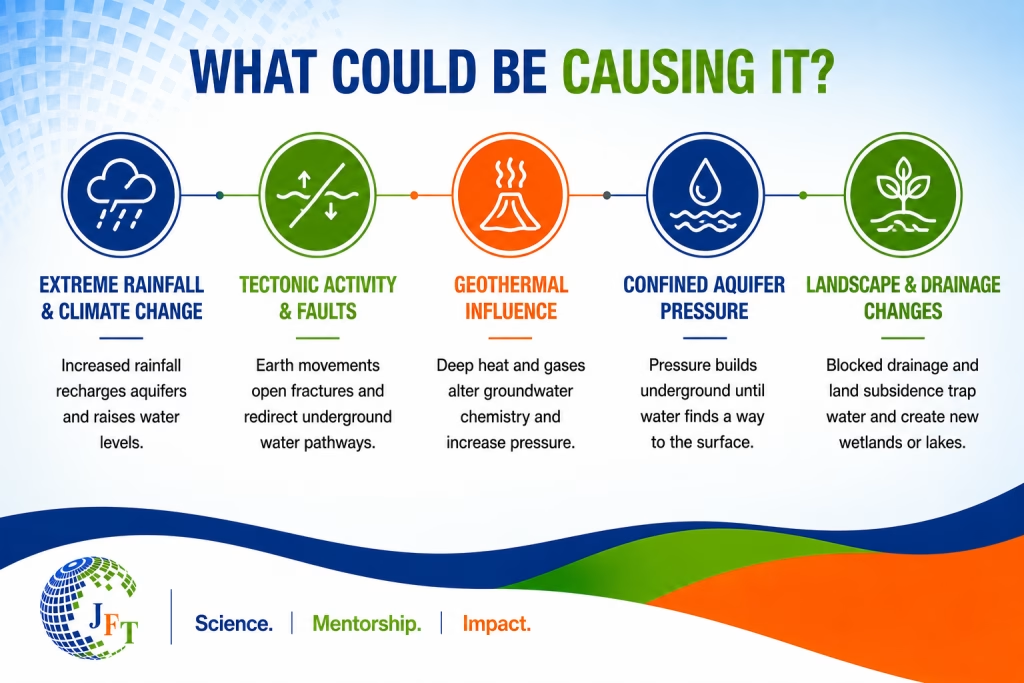
Scientists continue debating the precise combination of causes, but several major drivers have emerged.
Climate Change and Extreme Rainfall
One major explanation is climate variability and climate change.
Between approximately 2019 and 2024, Eastern Africa experienced multiple episodes of:
Above-average rainfall
Intense El Niño conditions
Increased surface runoff
Enhanced groundwater recharge
Flooding across major catchments
Several studies have shown that Rift Valley lakes are highly sensitive to changes occurring within surrounding catchments and groundwater systems.
When heavy rainfall persists over several seasons:
Rivers deliver more inflow into lakes
Groundwater recharge increases
Wetlands expand
Underground aquifers store more water
Subsurface pressure gradually rises
Eventually, this pressure may begin expressing itself in unexpected ways — including springs intensifying, wetlands emerging, or groundwater appearing in new locations.
Could Underground Water Systems Be Shifting?
While rising rainfall and surface flooding are major contributors to changing water conditions in the Rift Valley, scientists have also documented evidence that deeper underground geological and groundwater processes can influence how water moves and emerges at the surface.
The East African Rift is not geologically stable. It is an active tectonic system where the Earth’s crust continues to slowly stretch, fracture, and evolve. Because of this, groundwater movement in the region is often closely linked to faults, volcanic rocks, geothermal activity, and underground pressure systems.
Studies in the Kenyan and Ethiopian Rift have shown that faults and fractures can:
Redirect groundwater flow
Connect previously separate aquifers
Open new underground pathways
Alter spring discharge locations
Influence geothermal circulation systems
Hydrogeological research in the Central Kenya Rift has demonstrated that many hot springs and groundwater systems are structurally controlled by faults associated with Rift Valley tectonics. In geothermal regions such as Olkaria, Menengai, Bogoria, and Baringo-Silali, groundwater circulation is strongly influenced by volcanic fractures and deep fault systems.
For example:
In parts of the Kenyan Rift, geothermal springs have shifted location over time following tectonic activity and hydrological changes.
Studies around Lake Bogoria and the Baringo-Silali geothermal zone have linked hot spring occurrence to deep fault-controlled groundwater circulation.
Research in Ethiopia’s Rift Valley has documented how tectonic fractures influence both groundwater recharge and the emergence of springs.
Satellite observations and hydrological studies in Kenya have also shown expansion of wetlands and permanent inundation in some previously dry areas following prolonged periods of enhanced recharge and rising groundwater tables.
Importantly, this does not necessarily mean that tectonic movement alone is causing the Olkokwee groundwater emergence. Rather, scientists recognize that in Rift environments, climate-driven recharge, groundwater pressure, volcanic geology, and fault systems often interact together.
In hydrogeology, it is well established that when groundwater pressure increases within confined aquifers, water may naturally emerge through weak zones such as fractures or faults — especially in volcanic terrains where rocks are highly fractured.
This is why scientists investigating the Olkokwee groundwater eruption event would likely examine whether:
Groundwater tables have significantly risen in recent years
Fault systems exist beneath the affected area
Deep aquifers are connected to the surface through fractures
Geothermal or mineralized groundwater is involved
Regional lake expansion and groundwater recharge are influencing subsurface pressure systems
Across parts of the Rift Valley, communities have also observed environmental changes that align with documented hydrological shifts, including:
Intensification of springs
Expansion of wetlands
Permanently waterlogged zones
Changing geothermal expressions
Increased flooding in low-lying basins
The Olkokwee groundwater emergence may therefore represent a combination of extreme recharge, changing groundwater pressure, and the unique tectonic-geothermal setting of the Rift Valley rather than a single isolated cause.
The Mysterious Groundwater in Olkokwee, Baringo
The Olkokwee groundwater eruption has drawn growing concern because of both its sudden appearance and its unusual characteristics. Residents report that water began emerging directly from the ground, flooding homes, farms, and grazing land, and displacing families as the affected area expanded.
Unlike ordinary flooding caused mainly by rainfall runoff or overflowing rivers, this event appears to involve groundwater rising upward from beneath the surface — something that can occur in Rift Valley environments where underground aquifers, volcanic rocks, geothermal systems, and fault lines interact.
Scientists know that in tectonically active regions such as the Rift Valley, groundwater under pressure can sometimes emerge through fractures, old fault systems, weak volcanic rocks, or areas where groundwater tables have significantly risen after prolonged recharge. Such processes may create new springs, continuous seepage zones, bubbling or warm water, or flooding that appears to originate directly from the earth.
What makes the Olkokwee groundwater eruption event especially striking is that local reports suggest the water emerged suddenly, carries an unusual smell, affects nearby vegetation, and continues flowing rather than disappearing after rainfall subsides. These observations raise important hydrogeological questions because they may point to deeper groundwater movement, possible geothermal influence, chemically mineralized water, or pressure release from confined underground aquifers.
The reported smell could indicate sulfur-rich groundwater or dissolved geothermal gases such as hydrogen sulfide, which are commonly associated with volcanic and geothermal terrains in the Rift Valley. Meanwhile, stressed or dying vegetation may result from salinity, chemically altered groundwater, waterlogging, or changes in soil conditions caused by prolonged saturation.
Taken together, the Olkokwee event may represent more than ordinary flooding alone. It could be part of the broader environmental and hydrogeological changes increasingly being observed across the Rift Valley, where rising lakes, shifting wetlands, changing geothermal activity, and groundwater emergence may all be interconnected signals of a changing landscape.
The “bad smell” is a major clue
The reported smell associated with the groundwater is particularly important from a scientific perspective.
It may suggest the presence of dissolved volcanic or geochemical gases rising from deep underground systems.
In Rift Valley environments, possible gases include:
Hydrogen Sulfide (H₂S)
Hydrogen sulfide is commonly associated with geothermal systems.
It is known for:
A strong “rotten egg” smell
Association with volcanic or geothermal environments
Toxicity at high concentrations
Potential damage to vegetation and ecosystems
Sulfur-Rich Groundwater
Groundwater moving through volcanic rocks can dissolve sulfur-bearing minerals.
Such water may:
Alter soil chemistry
Affect plant growth
Produce strong odors
Change water quality significantly
Methane or Carbon Dioxide
Deep geological formations can also release gases such as methane or carbon dioxide.
In enclosed or low-lying areas, high concentrations of carbon dioxide can become dangerous to animals and humans.
If the groundwater is warm, bubbling, oily-looking, or highly mineralized, that would further strengthen evidence of geothermal influence.
Why plants may be dying
1. Salinity or Alkalinity
Many groundwater systems within the Rift Valley naturally move through volcanic and mineral-rich rocks before reaching the surface. During this process, the water can dissolve substances such as sodium, fluoride, sulfates, and carbonates. When these minerals accumulate in flooded soils, they may increase salinity or alkalinity, making it difficult for plants to absorb water and nutrients properly. Even when surrounded by water, vegetation can begin drying, weakening, or dying because the roots are no longer functioning normally. Over time, the soil itself may become less productive and increasingly hostile to plant growth.
2. Toxic Dissolved Elements
Groundwater influenced by geothermal or volcanic activity may also contain dissolved sulfur compounds, boron, fluoride, or trace heavy metals. In high concentrations, these substances can become toxic to vegetation and microorganisms living in the soil. Leaves may yellow or dry out, roots may become damaged, and sensitive plant species may begin disappearing from affected areas. Such chemical changes can gradually alter entire ecosystems around the flooded zones.
3. Waterlogging
Even ordinary freshwater can kill vegetation when flooding persists for long periods. When soils remain saturated, oxygen levels around plant roots decline significantly. Without oxygen, roots cannot properly absorb nutrients or maintain healthy growth. As a result, plants may wilt, decay, or collapse despite the presence of abundant water. Waterlogging can therefore transform previously productive land into stressed or dying landscapes.
4. Geothermal Heat
If the emerging groundwater is warm due to geothermal influence beneath the Rift Valley, the heat itself may place additional stress on vegetation and surrounding ecosystems. Warm groundwater can disrupt normal soil conditions, damage sensitive roots, and accelerate chemical reactions within the soil. In some geothermal regions around the world, heated groundwater has created barren or sparsely vegetated zones even in otherwise wet environments.
The Rift Valley May Be Rebalancing Itself
One of the most fascinating aspects of the current Rift Valley changes is that many processes appear interconnected.
As lakes rise:
Wetlands expand
Geothermal zones shift
Springs disappear or emerge
Groundwater pressure changes
Ecosystems reorganize
The submerged geysers of Lake Bogoria and the emerging groundwater in Olkokwee may not be isolated events.
They may both represent visible signs of a broader regional hydrological transformation.
The Rift Valley has always been dynamic.
But climate change, land-use change, tectonic activity, and increased groundwater recharge may now be accelerating environmental shifts that were previously slower or less visible
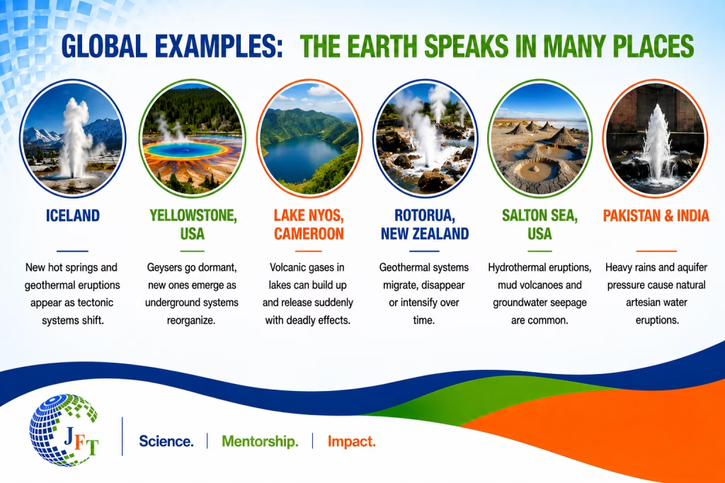
Similar Examples Around the World
The Olkokwee groundwater eruption and Rift Valley events may seem extraordinary, but similar groundwater and geothermal phenomena have occurred globally in tectonically active regions.
1. Iceland and Yellowstone National Park — Shifting Geothermal Systems
Some of the best-known examples of changing geothermal activity come from Iceland and Yellowstone National Park, both located within highly active volcanic and tectonic environments.
In Iceland, groundwater constantly interacts with volcanic heat beneath the Earth’s surface, creating hot springs, steam vents, geothermal eruptions, and sudden groundwater flooding. After earthquakes or volcanic activity, scientists have observed entire geothermal systems shifting location as underground fractures open, close, or redirect groundwater flow.
Yellowstone shows similar behavior. The park contains geysers, boiling springs, mud pots, and extensive hydrothermal systems connected through complex underground “plumbing” networks. Scientists have documented cases where some geysers suddenly become inactive while new springs emerge elsewhere. The famous Steamboat Geyser itself has experienced long periods of dormancy followed by renewed eruptions, demonstrating how underground geothermal systems can reorganize over time.
These examples show that in tectonically active regions, groundwater, geothermal heat, and underground pressure systems are constantly evolving — sometimes producing sudden visible changes at the surface.
2. Rotorua and the Salton Sea — Migration of Geothermal Activity
In Rotorua and the Salton Sea geothermal region, scientists have observed how geothermal and groundwater systems can gradually migrate or intensify due to underground pressure changes and tectonic activity.
Rotorua is famous for bubbling mud pools, hot springs, steam vents, and geysers. Over time, researchers discovered that some geothermal features weakened or disappeared while others became more active. These changes were linked to groundwater extraction, underground pressure redistribution, and shifting tectonic fractures that altered the movement of heated groundwater beneath the surface.
Similarly, the Salton Trough — itself an active rift system with some similarities to the East African Rift — experiences hydrothermal eruptions, mud volcanoes, geothermal gas emissions, and groundwater seepage. The region demonstrates how tectonic fault systems can create pathways for deep groundwater and geothermal fluids to rise toward the surface.
Together, these examples illustrate that geothermal systems are not fixed. They can expand, weaken, migrate, or suddenly emerge in new locations as underground conditions change.
3. Lake Nyos — Dangerous Underground Gas and Water Interactions
The tragedy at Lake Nyos in 1986 remains one of the world’s most important examples of the powerful relationship between groundwater, volcanic gases, and deep geological systems.
At Lake Nyos, large amounts of volcanic carbon dioxide had accumulated beneath the lake within deep geological formations. When the gas was suddenly released, it created a deadly cloud that killed more than 1,700 people and thousands of animals in nearby communities.
Although the situation for the Olkokwee groundwater eruption is very different and there is currently no evidence of a similar disaster, Lake Nyos demonstrated how underground geological processes can strongly influence surface water systems and how dissolved gases from deep within the Earth can emerge unexpectedly in tectonically active environments.
The event remains an important scientific reminder that Rift Valley and volcanic groundwater systems often involve complex interactions between geology, groundwater pressure, gases, and geothermal activity beneath the surface.
What scientists would urgently investigate
Understanding the Olkokwee groundwater eruption event would require a multidisciplinary scientific investigation because the phenomenon may involve interactions between groundwater systems, geology, climate, and geothermal activity beneath the Rift Valley. Each area of investigation would help answer different but connected questions about where the water is coming from, why it is emerging now, and whether similar events could occur elsewhere.
1. Hydrogeology — Understanding the Groundwater System
Hydrogeologists would first investigate how groundwater is moving beneath the area. This would include studying groundwater pressure, underground aquifer connections, recharge sources, and the rate at which the water is emerging at the surface.
Such investigations are important because they help determine whether the flooding is linked to rising groundwater tables, confined aquifers under pressure, or newly activated underground pathways connected to Rift Valley fault systems. Scientists would also want to know whether recent years of intense rainfall and lake expansion have increased subsurface groundwater storage across the region.
2. Geochemistry — Determining What Is in the Water
Water quality testing would be critical for understanding the unusual smell, vegetation stress, and possible geothermal influence associated with the groundwater.
Scientists would analyse the water for sulfur compounds, fluoride, salinity, dissolved gases, heavy metals, pH, and other dissolved minerals. These tests could reveal whether the water originated from shallow groundwater systems, deep geothermal aquifers, or mineral-rich volcanic formations beneath the Rift Valley.
Geochemical analysis is especially important because the chemical composition of groundwater often acts like a “fingerprint,” helping scientists trace where the water came from and what geological environments it passed through underground.
3. Geophysics — Investigating What Lies Beneath the Surface
Geophysicists would study underground structures such as faults, fractures, seismic activity, and possible ground deformation beneath the affected area.
This is important because Rift Valley groundwater movement is often strongly controlled by tectonic fractures and volcanic rocks. Mapping these hidden underground structures could help scientists determine whether groundwater is rising through deep fault systems or newly opened fractures linked to tectonic stress or pressure changes underground.
4. Remote Sensing — Seeing Regional Changes from Space
Satellite analysis and remote sensing would help scientists examine broader environmental changes occurring across the Rift Valley landscape.
Using satellite imagery, researchers could monitor lake expansion, vegetation stress, changing surface moisture, wetland growth, and land subsidence over time. These observations are important because they help place the Olkokwee groundwater eruption event within the wider context of regional hydrological and environmental change.
By combining field investigations with satellite monitoring, scientists may better understand whether similar underground processes are occurring elsewhere across the Rift Valley.
Listening to the Rift Valley’s Heart Beat
The recent groundwater emergence in Olkokwee should not only be viewed as a local disaster affecting homes, farms, and livelihoods. It may also represent an important scientific signal from one of the world’s most geologically active regions.
Across the Rift Valley, signs of environmental change have become increasingly visible — disappearing geysers in Lake Bogoria, expanding lakes, shifting wetlands, intensified springs, and now groundwater reportedly emerging directly from beneath the earth in parts of Baringo.
These events may reflect deeper interactions between climate change, groundwater recharge, tectonic activity, geothermal systems, and surface water dynamics. While each event may appear isolated, scientists increasingly recognize that many Rift Valley processes are interconnected through complex underground hydrological and geological systems.
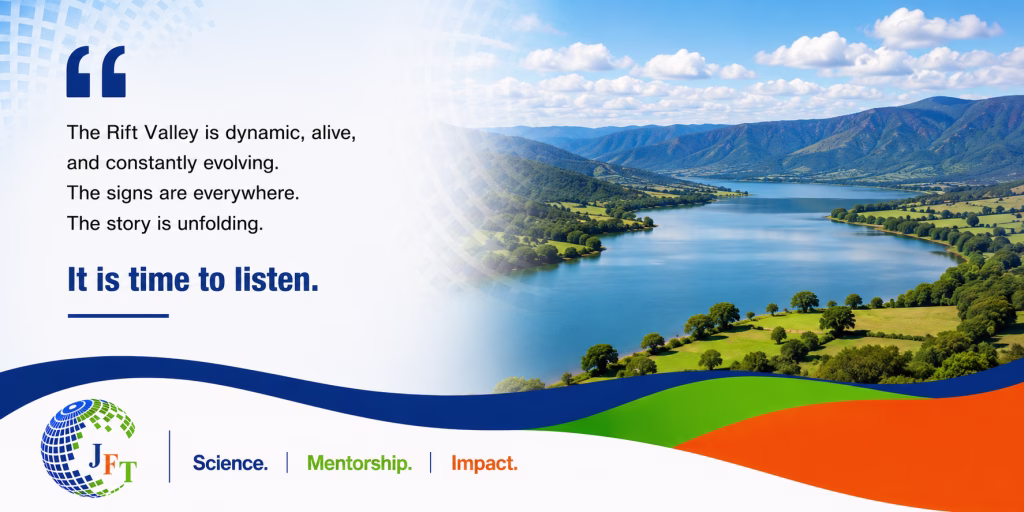
The Rift Valley has always been a landscape shaped by movement, pressure, heat, and water. What may be changing today is the speed and visibility with which these processes are appearing at the surface.
The disappearing geysers of Lake Bogoria, the rising Rift Valley lakes, and the mysterious groundwater emergence in Olkokwee may therefore represent connected chapters of a much larger environmental story — one written slowly beneath the earth, but now becoming increasingly visible across the landscape.
For generations, communities living around the Rift Valley have learned to coexist with a landscape shaped by fire, water, earthquakes, volcanoes, and powerful underground forces. People understood that the Valley was alive — sometimes calm, sometimes unpredictable, but always moving in its own quiet rhythm. But lately, the Rift Valley seems to be speaking a little louder. Lakes are expanding. Geysers are disappearing. Wetlands are emerging where dry land once existed. And now, in parts of Baringo, the ground itself appears to be producing water from below as if the earth has decided to install its own taps. Perhaps none of this is entirely new. The Rift Valley has always been dynamic. What may be changing is the speed, scale, and visibility of these transformations — driven by the complex interaction between climate, groundwater, tectonics, and geothermal systems. In many ways, the Valley behaves less like a fixed landscape and more like a living geological machine constantly adjusting itself beneath our feet. And maybe that is the real lesson here: the Rift Valley is not broken. It is active. It is evolving. It is breathing through lakes, springs, faults, and underground water systems. The challenge for us is learning how to listen before the next “surprise” decides to emerge from the ground.”
Dr. Florence Tanui (Ph.D)
Groundwater & Water Security Expert
I am an expert at the science–policy interface on groundwater governance, water security, and climate resilience, with a focus on African and climate-vulnerable contexts. My work involves applied hydrogeological analysis, risk assessment, decision support, and institutional strengthening, including engagement in transboundary groundwater dialogue and regional cooperation processes. I contribute to programme design, policy dialogue, and capacity development, translating groundwater data and systems understanding into actionable guidance for governments, development partners, and implementing agencies.