

Groundwater resilience is becoming a defining challenge for African cities as climate variability, rapid urbanization, rising water demand, and declining reliability of some surface-water sources place increasing pressure on freshwater systems. Beneath the ground lies a strategic resource capable of buffering communities against seasonal droughts and rainfall variability, but aquifers are not inexhaustible reserves.
Where groundwater abstraction exceeds natural replenishment, water levels can decline, pumping costs can rise, and water quality can deteriorate. Strengthening groundwater resilience therefore requires more than drilling additional boreholes; it demands a scientifically informed approach to aquifer management, urban planning, monitoring, and long-term water security.
Global terrestrial water storage has been in a persistent, decade-long decline, making water scarcity an immediate reality for urban planners, policymakers, and African communities. As surface reservoirs dry up and rainfall patterns become increasingly erratic, the spotlight has shifted entirely beneath our feet. This crisis is a central part of how climate risks are quietly reshaping the future of African cities, making true groundwater resilience no longer a distant environmental goal for these urban centers; it is a matter of immediate survival.
The objective is not simply to extract more water from underground. It is to ensure that groundwater remains a reliable, safe and sustainable resource for future generations.

The Hidden Crisis: Understanding Groundwater Storage and Depletion
Unlike rivers, reservoirs and lakes, groundwater depletion is often difficult to observe directly. Changes can occur gradually beneath the surface, becoming apparent only when borehole yields decline, pumping depths increase, springs weaken or water quality changes.
Groundwater is stored in geological formations known as aquifers. These formations differ considerably in their capacity to store and transmit water. Their characteristics depend on factors such as rock type, fractures, porosity, permeability, geological structure and the rate at which recharge occurs.
In rapidly growing urban centres such as Nairobi, Lagos and Lusaka, increasing demand can place substantial pressure on groundwater resources. Where surface-water supplies are unreliable or distribution networks fail to meet demand, households, industries and institutions may increasingly depend on private boreholes. If extraction is poorly monitored, cumulative abstraction can exceed the rate of replenishment.
However, declining groundwater levels do not necessarily mean that an aquifer is approaching complete exhaustion. The extent and consequences of depletion depend on aquifer characteristics, recharge conditions, abstraction rates and the connectivity between groundwater and surrounding rivers, wetlands and other water bodies.
The distinction matters because effective intervention must be based on measured conditions rather than assumptions.
Satellite observations, including data from the Gravity Recovery and Climate Experiment (GRACE) and its follow-on mission, have revealed substantial changes in terrestrial water storage across several regions of the world. These observations help scientists assess broad changes in water storage, but they do not independently establish the condition of every local aquifer. Ground-based measurements and hydrogeological investigations remain essential for determining what is happening beneath a particular city.
For African cities, the priority is to identify vulnerable aquifers before declining water availability becomes a major economic, environmental or public-health problem.
Defining Groundwater Resilience in an Urban Context
Groundwater resilience refers to the capacity of an aquifer system, together with the infrastructure and institutions that depend on it, to withstand water-related pressures while maintaining a reliable supply without unacceptable long-term environmental damage.
This includes the ability to cope with prolonged dry periods, recover from temporary stress where recovery is physically possible, maintain acceptable water quality and support communities through changing climatic conditions.
Groundwater resilience rests on several interconnected foundations.
Aquifer productivity and storage: Understanding how much water an aquifer can store and transmit, how quickly it is replenished, and how its performance changes under sustained abstraction.
Recharge and recovery capacity: Determining how rainfall, river infiltration, soil conditions, geology and land use contribute to replenishing groundwater reserves.
Water quality protection: Preventing contamination from poorly managed sanitation, industrial discharges, agricultural chemicals, waste disposal and saline intrusion where relevant.
Infrastructure integrity: Ensuring boreholes are properly designed, constructed, maintained and monitored to reduce mechanical failure, contamination pathways and uncontrolled abstraction.
Institutional and community capacity: Establishing the regulations, financing, technical expertise and data systems needed to manage groundwater as a shared resource.
These foundations demonstrate why groundwater resilience cannot be achieved through infrastructure investment alone. Boreholes may increase access to water, but without adequate resource assessment and management, additional abstraction can intensify the very problem the infrastructure was intended to solve.
A Blueprint for Strengthening Groundwater Resilience
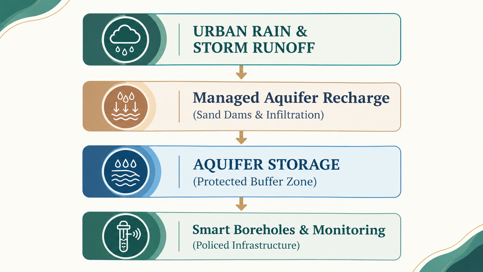
This framework illustrates how groundwater resilience can be strengthened by connecting urban stormwater management with managed aquifer recharge, protected groundwater storage and monitored abstraction. Its success depends on suitable geological conditions, adequate water-quality controls, effective recharge design and enforceable abstraction limits. The objective is to transform stormwater from a potential source of urban flooding into a resource that can support water security, where site-specific assessments demonstrate that recharge is safe and feasible.
Strengthening groundwater resilience requires a shift from reactive extraction toward planned, evidence-based management. Geoscience, engineering, digital monitoring, and effective urban policy can work together to protect aquifers and improve the reliability of water supplies.
1. Accelerating Managed Aquifer Recharge
Managed Aquifer Recharge (MAR) involves intentionally directing suitable water into an aquifer for storage and later use, or to support groundwater-dependent ecosystems where appropriate.
Potential approaches include infiltration basins, recharge trenches, carefully designed recharge wells, restored wetlands and suitable stormwater-management systems. In some rural and peri-urban settings, sand dams and subsurface barriers can also help retain water and increase local infiltration when the geological and hydrological conditions are appropriate.
For cities experiencing intense rainfall followed by dry periods, MAR may help capture a portion of stormwater that would otherwise leave the catchment as rapid runoff. However, recharge is not simply a matter of directing floodwater underground.
Before a recharge scheme is implemented, technical assessments should establish:
- Whether the underlying geology can accept and store additional water.
- Whether sufficient unsaturated storage space exists.
- Whether the proposed water source is chemically and microbiologically suitable.
- Whether infiltration could mobilize existing contaminants.
- Whether recharge could affect nearby buildings, infrastructure or groundwater-dependent ecosystems.
- Whether the stored water can be recovered or will contribute to a beneficial environmental outcome.
Urban stormwater can contain sediment, hydrocarbons, pathogens, metals and other contaminants. Appropriate treatment, site selection and ongoing water-quality monitoring are therefore essential.
A well-designed MAR project should include baseline groundwater measurements, recharge-rate testing, water-quality assessment, operational controls and post-implementation monitoring. Its performance should be evaluated against measurable outcomes, including changes in groundwater levels, recovered water volumes, water quality and the cost per unit of water reliably stored.
Managed Aquifer Recharge is not suitable for every aquifer, but where conditions are favourable, it can become an important component of a broader groundwater resilience strategy.
2. Investing in Hydrogeological Mapping and Digital Monitoring
You cannot manage an aquifer effectively if you do not understand its structure, behaviour and limits.
Hydrogeological mapping provides the foundation for identifying aquifer boundaries, recharge zones, groundwater-flow directions, vulnerable areas and locations where abstraction may be placing excessive pressure on the resource.
Modern geoscience tools can strengthen this understanding. Geographic Information Systems (GIS), remote sensing, geological mapping, geophysical surveys and groundwater modelling can be integrated to produce a more complete picture of subsurface conditions.
For larger urban areas, a groundwater digital twin can be developed as a continuously updated representation of the aquifer system. Depending on data availability, it may integrate borehole records, geological information, groundwater-level observations, abstraction estimates, water-quality measurements, rainfall and land-use changes.
Scientists and water managers can then use the model to investigate scenarios such as:
- What happens if groundwater demand increases substantially?
- Which areas are most vulnerable to declining groundwater levels?
- How might a prolonged drought affect borehole performance?
- Where could additional recharge provide the greatest benefit?
- How might changes in abstraction affect connected rivers, wetlands or neighbouring users?
Digital models are only as reliable as the information used to construct and calibrate them. They should therefore be supported by field observations, regular updates, transparent assumptions and independent technical review.
A practical monitoring network can include strategically placed observation wells, water-level loggers, abstraction meters and periodic water-quality sampling. Automated sensors can transmit measurements to a central platform, helping authorities detect unusual changes and investigate emerging problems earlier.
The result is a more proactive approach to groundwater resilience: one based on observed aquifer behaviour rather than waiting for boreholes to fail.
3. Enforcing Sustainable Groundwater Abstraction
Groundwater governance is a critical part of long-term water security.
Where boreholes are drilled without adequate assessment or abstraction is poorly regulated, the combined effect of many individual users can place an aquifer under considerable stress. A borehole may appear productive in isolation while contributing to a wider pattern of declining groundwater levels.
Authorities should strengthen licensing, registration, abstraction reporting and compliance monitoring. High-volume users, including commercial and industrial facilities, may require more intensive monitoring and clearer abstraction limits.
However, regulation should be informed by hydrogeological evidence. Sustainable abstraction cannot be determined by applying one universal pumping limit to every borehole or aquifer.
The appropriate limit depends on aquifer properties, recharge, existing withdrawals, water quality, environmental requirements and the potential effects on other users. In some settings, management must also account for groundwater movement across administrative boundaries.
Groundwater resilience planning should therefore include regular reviews of abstraction permits, cumulative demand and observed water-level trends. Where monitoring indicates persistent decline or unacceptable environmental effects, authorities may need to reduce withdrawals, redistribute demand or develop alternative supplies.
Enforcement should be accompanied by accessible information, clear procedures and engagement with communities and businesses. This helps ensure that groundwater protection is understood as a shared responsibility rather than simply a regulatory burden.
4. Integrating Groundwater Protection into Urban Planning
Urban development can either support or undermine groundwater recharge.
Expanding paved surfaces, compacted soils and poorly planned drainage systems can reduce infiltration and accelerate runoff. Development over important recharge zones may restrict the movement of water into underlying aquifers, while inadequate sanitation and waste management can introduce contaminants into groundwater.
Groundwater resilience should therefore become part of urban spatial planning.
Municipal authorities can identify and protect important recharge areas, maintain suitable green spaces, incorporate permeable surfaces where appropriate and use sustainable urban drainage systems to manage stormwater closer to where it falls.
These measures must be adapted to local conditions. Permeable paving, for example, may be unsuitable in areas with contaminated soils or where infiltrating water could threaten building foundations. Recharge projects also require consideration of the depth of the water table and the vulnerability of the underlying aquifer.
Urban planning should additionally protect wetlands, riparian corridors and other areas that contribute to water retention or support groundwater-dependent ecosystems.
The objective is to treat the urban landscape as part of the water-management system. Roads, buildings, drainage networks and open spaces influence how rainfall moves through a catchment and, ultimately, how much water may become available for groundwater recharge.
5. Protecting Groundwater Quality Before Contamination Occurs
Groundwater quality is as important as groundwater quantity.
An aquifer with substantial stored water may still be unsuitable for drinking or other uses if contamination exceeds acceptable limits. Unlike some surface-water pollution, contamination within an aquifer can be difficult, expensive and slow to reverse.
Potential sources include leaking sanitation systems, poorly managed landfills, industrial activities, fuel storage, agricultural chemicals and inadequately constructed or abandoned boreholes.
A groundwater protection programme should identify contamination sources, map vulnerable recharge areas, establish water-quality baselines and implement risk-based monitoring.
Testing should be tailored to local geology and land use. Depending on the setting, parameters may include electrical conductivity, pH, nitrate, fluoride, major ions, metals and microbiological indicators.
Where contamination is detected, authorities should investigate its source and movement rather than relying solely on treatment at the point of consumption. Protective measures may include improving sanitation, controlling discharges, rehabilitating boreholes, restricting certain activities in sensitive recharge zones and providing safe alternative supplies where necessary.
Protecting water quality at the source is often more effective than attempting to restore a contaminated aquifer after the damage has occurred.
Scalable Models: Lessons from Regional Groundwater Cooperation
Groundwater systems frequently extend beyond the boundaries of individual municipalities or countries. Their management can therefore require cooperation between institutions that share geological formations, water resources and technical challenges.
Regional programmes provide useful examples of how infrastructure investment, scientific assessment and institutional coordination can support groundwater resilience.
The World Bank-supported Horn of Africa Groundwater for Resilience Project illustrates the importance of improving groundwater access and strengthening resilience in a region exposed to recurrent drought and water insecurity. Its relevance extends beyond individual boreholes: long-term outcomes also depend on resource assessment, service delivery, institutional capacity and sustainable operation.
Similarly, the Groundwater for Advancing Resilience in Africa (G4DR) initiative highlights the importance of managing transboundary aquifers. Because underground water systems do not respect national borders, regional geoscience cooperation led by the International Water Management Institute (IWMI) is paramount to ensuring that one city’s survival plan does not inadvertently dry out its neighbor’s supply.
Regional cooperation is particularly important for transboundary aquifers. Groundwater abstraction in one location can, under certain hydrogeological conditions, influence groundwater levels or flows elsewhere. The scale and timing of those effects depend on the characteristics of the aquifer and cannot be assumed to be identical across all shared systems.
Effective cooperation requires shared data, compatible monitoring methods, clear institutional responsibilities and mechanisms for resolving competing demands.
For African cities, the lesson is that local groundwater management should be informed by the wider hydrogeological system. Sustainable decisions require an understanding of where groundwater comes from, how it moves, who depends on it and what happens when abstraction changes.
An Actionable Strategy for Municipalities
A practical groundwater resilience programme should translate scientific findings into operational decisions. The following framework identifies priority actions and their intended outcomes.
| Priority action | Implementation approach | Intended outcome |
|---|---|---|
| Protect recharge areas | Map vulnerable zones and integrate them into land-use plans | Preserve opportunities for natural recharge |
| Monitor boreholes | Register wells, measure abstraction and track groundwater levels | Identify overuse and emerging declines |
| Develop recharge projects | Assess suitable sites, source-water quality and storage capacity | Increase beneficial recharge where feasible |
| Improve water-quality surveillance | Establish baselines and conduct risk-based sampling | Detect contamination before exposure expands |
| Model aquifer behaviour | Combine geological data, monitoring and demand scenarios | Support evidence-based abstraction and investment decisions |
| Diversify water supplies | Coordinate surface water, groundwater, reuse and conservation | Reduce dependence on a single source |
| Strengthen institutional coordination | Share data and clarify responsibilities across agencies | Improve compliance and long-term resource management |
These interventions should be prioritized according to local risk, expected benefits, technical feasibility and available funding.
For example, an urban area experiencing rapidly declining groundwater levels may need an immediate abstraction assessment and monitoring programme before investing in new recharge infrastructure. A city with suitable geology but severe stormwater runoff may benefit from carefully designed recharge pilots. Where contamination is the principal concern, source protection and sanitation improvements may deliver greater benefits than increasing extraction.
The most effective investment is the one that addresses the dominant cause of vulnerability in the aquifer system.
Conjunctive Water Management: Using Groundwater and Surface Water Together
Groundwater resilience should not be confused with replacing every other water source with groundwater. In many locations, a more reliable strategy involves managing groundwater and surface water together.
This approach, commonly called conjunctive water management, coordinates the use of rivers, reservoirs, groundwater, rainwater and other suitable sources according to their availability, quality, infrastructure requirements and environmental limits.
Where surface-water supplies are abundant and treatment capacity is available, groundwater abstraction may be reduced to allow recovery where the aquifer can respond. During droughts, groundwater may provide a buffer, provided that abstraction remains within appropriate limits and the resource is suitable for the intended use.
The strategy requires more than switching sources between wet and dry seasons. Decisions must account for seasonal recharge, reservoir operations, groundwater response times, water quality, pumping costs and the needs of ecosystems and other users.
A well-designed conjunctive management plan can reduce pressure on individual sources, increase operational flexibility and improve preparedness for climate variability.
However, it cannot eliminate water scarcity where total demand consistently exceeds the available sustainable supply. Demand management, leakage reduction, efficient irrigation, wastewater reuse and investment in appropriate infrastructure remain essential.
From Data to Decisions: What a Groundwater Resilience Assessment Should Include
For water authorities, development agencies and infrastructure planners, the first step toward stronger groundwater resilience should be a structured diagnostic assessment.
A comprehensive assessment would bring together several technical workstreams.
Hydrogeological assessment: Characterize aquifer geometry, geological formations, hydraulic properties, groundwater-flow directions and recharge conditions.
Groundwater-level and abstraction assessment: Establish baseline water levels, compile borehole records, estimate withdrawals and identify locations experiencing persistent decline.
Water-quality assessment: Determine the chemical and microbiological condition of groundwater and identify potential contamination sources.
Climate and recharge assessment: Examine rainfall variability, drought patterns, land cover, runoff and the factors controlling groundwater replenishment.
Modelling and scenario analysis: Evaluate future demand, alternative abstraction levels, potential recharge interventions and the likely effects of climate variability.
Infrastructure and institutional assessment: Review borehole condition, monitoring capacity, regulatory arrangements, maintenance requirements and financing.
Socioeconomic assessment: Identify communities and economic activities most dependent on groundwater, assess affordability and consider how changes in supply would affect vulnerable users.
The findings should lead to a prioritized action plan rather than a report that simply describes the problem. Each recommended intervention should have an identified responsible institution, implementation timeline, estimated cost, monitoring indicators and criteria for evaluating success.
This is where geoscience becomes directly useful to policy and investment decisions.
Measuring Success: Indicators That Matter
Groundwater resilience should be evaluated through measurable changes in aquifer condition, service reliability and management performance.
Useful indicators include:
- Trends in groundwater levels at monitored locations.
- Changes in abstraction relative to estimated recharge and environmental requirements.
- Borehole yield, reliability and downtime.
- Compliance with drinking-water quality standards.
- The proportion of high-volume boreholes with functioning meters.
- The condition and protection of priority recharge zones.
- The volume of water beneficially recharged and, where relevant, recovered.
- The cost and reliability of groundwater supply.
- The number of communities with dependable access to safe water.
No single indicator provides a complete picture. Groundwater levels can vary naturally, and recharge estimates may carry substantial uncertainty. Indicators should therefore be interpreted together and reviewed over time.
The purpose of monitoring is not simply to generate data. It is to determine whether management interventions are improving the condition of the resource and the reliability of the services that depend on it.
The Decisive Decade Ahead
Groundwater resilience will increasingly influence how African cities manage drought, urban growth, climate variability and water insecurity. But resilience cannot be achieved by treating aquifers as bottomless reservoirs or assuming that deeper drilling will always provide a solution.
Groundwater is part of a dynamic system shaped by geology, rainfall, land use, surface-water interactions and human demand. Protecting it requires accurate assessment, continuous monitoring, responsible abstraction and coordinated planning.
The priorities are clear: understand the aquifer before expanding extraction, protect recharge areas before urban development removes them, monitor water quality before contamination becomes widespread, and invest in models and data systems that allow authorities to anticipate emerging risks.
For governments, utilities, development partners and technical institutions, the opportunity is to move from fragmented responses toward integrated groundwater management supported by evidence and measurable outcomes.
The future of urban water security will depend not only on how much groundwater can be extracted today, but on how effectively the resource is protected, replenished where feasible and managed for tomorrow.