

The Lake Baringo and Lake Bogoria merging crisis is no longer simply a question of two Rift Valley lakes getting closer together. It is a warning that the hydrological behaviour of one of Kenya’s most environmentally sensitive landscapes is changing and that communities, infrastructure, ecosystems, and local economies are being exposed to increasingly complex water-related risks.
Recent reporting has placed the distance between the expanding waters of Lake Baringo and Lake Bogoria at less than 3 kilometres, while government agencies have intensified assessments and interventions around the two lakes. Kenya’s Climate Change Directorate has also completed a multi-agency loss-and-damage assessment covering the social, economic, environmental, and infrastructure impacts of rising water levels.
But from a hydrological perspective, the most important question is not simply whether Lake Baringo and Lake Bogoria will merge.
The more important questions are: What is driving the rising water levels? Where is the additional water coming from? How are surface water and groundwater interacting? What would happen if Lake Bogoria overflowed into Lake Baringo? And which interventions can reduce the risk before the situation becomes irreversible?
These questions require much more than emergency flood response. They require hydrology, hydrogeology, water-quality science, GIS, remote sensing, climate analysis, ecological assessment and engineering to work together.
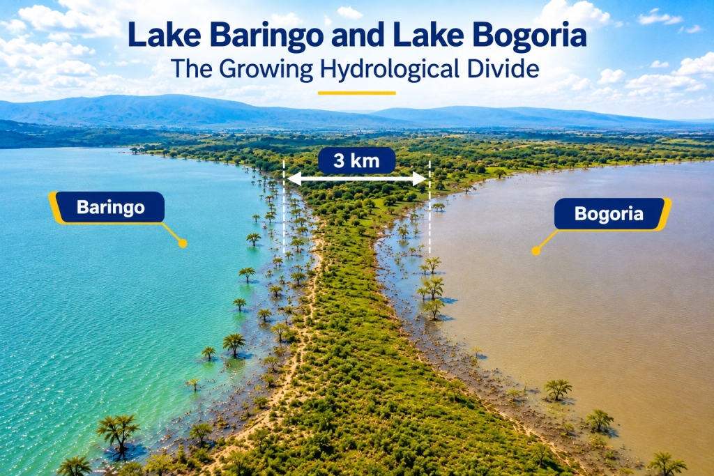
Lake Baringo and Lake Bogoria: Why the Situation Is More Complicated Than It Looks
At first glance, the crisis appears straightforward: water levels are rising, shorelines are expanding and the distance between two lakes is shrinking.
But a lake is not an isolated body of water.
It is the visible component of a much larger catchment system involving rainfall, rivers, runoff, groundwater, soils, wetlands, evaporation, land use and human activity.
Lake Baringo itself has been experiencing significant changes in water levels. A 2024 study using GIS and remote sensing identified rainfall, land-use changes, soil erosion and siltation among the factors relevant to the lake’s changing water levels and modelled continued increases under its scenarios.
The Lake Baringo and Lake Bogoria merging crisis therefore needs to be understood as a basin-scale water-balance problem, rather than simply a shoreline problem.
A useful way of thinking about it is:
Water entering the system − water leaving the system = change in stored water.
When rainfall and runoff increase while evaporation and other losses do not compensate for that additional water, lake storage increases.
If that continues over several years, the consequences can extend far beyond the lake itself.
The Hydro-Dynamics of the Rift Valley Basins
The Rift Valley is a naturally dynamic hydrological environment. Its lakes occupy depressions within a complex geological and topographical landscape, and several are highly sensitive to changes in rainfall and catchment runoff.
These changes are part of a broader pattern of how climate change is reshaping water systems in African cities, where changing rainfall patterns and more intense precipitation are increasingly affecting water availability, flooding and infrastructure resilience.
The recent behaviour of the region demonstrates how quickly those systems can respond to changing climate conditions.
A peer-reviewed study examining whether Lake Bogoria could overflow into Lake Baringo found substantial changes in regional rainfall and hydrology since around 2010. The researchers reported that intense rainfall days had increased substantially and concluded that Lake Bogoria could reach its spill point under sufficiently high lake levels.
This matters because extreme rainfall does not simply increase the amount of water falling directly onto the lake.
It can also increase:
- river discharge;
- surface runoff;
- soil erosion;
- sediment transport;
- groundwater recharge;
- wetland inundation;
- floodplain saturation; and
- the amount of water reaching downstream and terminal lake systems.
The result can be a rapid change in the regional water balance.
Catchment degradation makes the problem worse
Climate variability is only one part of the story.
The condition of the catchment determines how rainfall becomes runoff.
Where vegetation has been removed, soils degraded and slopes exposed to erosion, rainfall that might previously have infiltrated into the soil or been temporarily stored by vegetation can move more rapidly across the landscape.
Deforestation, overgrazing, cultivation on vulnerable slopes, poor drainage and uncontrolled development can therefore change the runoff coefficient of a catchment.
In simple terms:
A degraded catchment can turn rainfall into runoff faster and more efficiently than a healthy catchment.
That additional runoff eventually has to go somewhere.
Some of it reaches rivers.
Some enters wetlands.
Some infiltrates into groundwater.
And some ultimately contributes to lake storage.
This is why protecting the lakes without protecting their catchments is unlikely to provide a lasting solution.
What Could Happen If Lake Bogoria Overflows Toward Lake Baringo?
The possibility of a hydraulic connection between the two lakes is not merely theoretical.
A 2024 study specifically investigated the risk of Lake Bogoria, an alkaline lake, overflowing toward freshwater Lake Baringo. The researchers found that, relative to the maximum level observed in 2020, approximately 0.7 metres of additional rise would have been sufficient to reach the identified spill point in their analysis. They also estimated that, under spill-point conditions and certain rainfall assumptions, average annual flow toward Baringo could potentially reach hundreds of litres per second.
Importantly, this does not mean that a permanent merger is inevitable.
Lake levels fluctuate.
The hydrological conditions that produced the risk in one period can change.
The study itself noted that a substantial decline in Bogoria’s level in 2023 reduced the estimated overflow risk.
However, the existence of a scientifically modelled overflow pathway means the possibility deserves serious monitoring.
And this is where the phrase “Lake Baringo and Lake Bogoria merging” can become misleading.
The immediate scientific concern is not necessarily that two lakes will suddenly become one giant lake.
The concern is the possibility of hydrological connection and cross-mixing between two systems with very different ecological and chemical characteristics.
That distinction is critical.
The Hydro-Chemical Catastrophe: What Happens When Two Different Water Systems Connect?
Perhaps the most underappreciated aspect of the Lake Baringo and Lake Bogoria merging crisis is water chemistry.
Lake Baringo and Lake Bogoria are not chemically identical systems.
Lake Bogoria is well known as a saline-alkaline lake, while Lake Baringo is a freshwater system. Scientific literature has long recognized the distinctive chemistry of East African Rift lakes, with Bogoria among the region’s soda-rich waters.
Therefore, if significant volumes of Bogoria water were to enter Baringo, the issue would not simply be:
“More water has entered the lake.”
It would be:
“A chemically different water mass has entered a freshwater ecosystem.”
That could have consequences for water chemistry, aquatic organisms, fisheries and human and livestock water use.
Salinity and conductivity
One of the first parameters that would require close monitoring is electrical conductivity.
Changes in conductivity can provide an early indication that the chemical composition of water is changing.
Other parameters should include:
- pH;
- electrical conductivity;
- total dissolved solids;
- alkalinity;
- temperature;
- dissolved oxygen;
- turbidity;
- major ions;
- nutrients; and
- fluoride and other constituents relevant to local water use.
The critical point is that the consequences would depend on the volume, concentration, duration and spatial distribution of the inflow.
It would therefore be scientifically inappropriate to simply declare that an overflow would automatically “poison” Lake Baringo.
Instead, the correct response is to measure, model and monitor the chemical consequences before and during any significant hydraulic connection.
Could Freshwater Fisheries and Biodiversity Be Affected?
Absolutely, the possibility deserves serious ecological assessment.
Freshwater organisms are adapted to particular environmental conditions.
Changes in:
- salinity;
- pH;
- dissolved oxygen;
- temperature;
- nutrient concentrations;
- turbidity; and
- ionic composition
can alter aquatic habitats.
The impacts would not necessarily occur uniformly across the lake.
Some species could be more sensitive than others.
Some habitats could become unsuitable.
Food webs could change.
Fish populations could be affected.
Plankton communities could shift.
Bird feeding patterns could change.
And wetlands connected to the lake system could also be affected.
This is especially important because Lake Bogoria itself supports a distinctive alkaline ecosystem associated with large concentrations of flamingos and other wildlife.
Therefore, the Lake Baringo and Lake Bogoria merging crisis should be understood as a potential ecosystem-transition event, not simply a flooding event.
The correct scientific question is:
What ecological state would emerge if the chemistry, hydrology and connectivity of the two systems changed?
Answering that question requires baseline ecological and water-quality data before major cross-mixing occurs.
The Hidden Crisis Beneath the Surface: Groundwater
One of the most important issues in the Lake Baringo and Lake Bogoria merging crisis may be occurring underground.
Lake levels and groundwater levels are closely connected in many lake systems.
When lake levels rise substantially, hydraulic gradients can change.
Groundwater tables can rise.
Soils can become saturated.
Drainage systems can become ineffective.
And areas that appear safe from surface flooding can begin experiencing water-related damage.
This matters because infrastructure does not necessarily have to be submerged before it is affected.
Rising groundwater can contribute to:
- foundation problems;
- saturated soils;
- road deterioration;
- septic-system failure;
- agricultural losses;
- borehole-quality changes;
- wetland expansion;
- structural damage; and
- persistent waterlogging.
This is why simply looking at satellite images of the lake shoreline is not enough.
A proper assessment requires groundwater monitoring.
What should be monitored?
A basin-wide hydrogeological investigation could include:
- piezometers;
- groundwater-level measurements;
- borehole inventories;
- hydraulic-head mapping;
- groundwater conductivity;
- groundwater chemistry;
- aquifer characterization;
- geological mapping; and
- groundwater–surface-water interaction studies.
Isotope hydrology can add another layer
Isotope hydrology can help scientists investigate questions such as:
- Where is groundwater coming from?
- How quickly is water moving through the system?
- Are groundwater and lake water connected?
- Which sources contribute to particular water bodies?
- How long has water been stored underground?
This is particularly useful where conventional water-level monitoring cannot fully explain the movement of water.
Why Building Dykes Alone Will Not Solve the Lake Baringo and Lake Bogoria Crisis
Emergency engineering interventions have an important role.
If homes, roads, hospitals or other critical infrastructure are immediately threatened, temporary or permanent flood-protection structures may be necessary.
But there is a fundamental engineering principle:
A barrier does not eliminate water; it redirects or stores it.
An earth dyke may protect one location while increasing hydraulic pressure or flood exposure elsewhere.
Without proper design, a dyke can be vulnerable to:
- overtopping;
- erosion;
- seepage;
- piping;
- foundation failure;
- inadequate freeboard;
- drainage failure; and
- prolonged hydraulic loading.
This does not mean dykes are ineffective.
It means they must be part of a larger hydraulic strategy.
A properly designed intervention should answer:
What happens to the water after the structure is built?
Where will it flow?
What happens during a 1-in-50-year or 1-in-100-year event?
What happens if rainfall exceeds historical conditions?
What happens when groundwater rises?
What happens if sediment blocks drainage channels?
These questions require hydrodynamic modelling rather than visual assessment alone.
Hydrodynamic Modelling Can Change How the Crisis Is Managed
Modern water-resource management should not rely exclusively on historical observations.
The Lake Baringo and Lake Bogoria merging crisis requires scenario-based modelling.
Using tools such as GIS, digital elevation models and hydrodynamic models such as HEC-RAS, technical teams can investigate different flood and overflow scenarios.
For example:
Scenario 1: Moderate lake-level rise
Which settlements and infrastructure become exposed?
Scenario 2: Extreme rainfall
How quickly does water move through the catchment?
Scenario 3: Continued lake expansion
Which roads, farms and public facilities become progressively vulnerable?
Scenario 4: Lake Bogoria reaches the spill threshold
Where would water initially travel?
Scenario 5: Sustained overflow
How would water move across the intervening landscape?
Scenario 6: Overflow combined with extreme rainfall
What is the worst credible scenario?
This approach transforms the question from:
“Will the lakes merge?”
into:
“What happens under each plausible hydrological scenario, and where should intervention occur first?”
That is a far more useful question for government and development planners.
GIS and Remote Sensing Should Become Part of the Monitoring System
The geography of the crisis is changing continuously.
Satellite data can provide repeated observations of:
- lake surface area;
- shoreline movement;
- flooded land;
- vegetation changes;
- wetland expansion;
- sediment plumes;
- infrastructure exposure; and
- changes in land use.
GIS can then combine those observations with:
- elevation;
- roads;
- settlements;
- schools;
- health facilities;
- farms;
- boreholes;
- drainage networks;
- geological information; and
- population data.
The result is a spatial risk map.
Instead of saying:
“The lake is approaching communities,”
decision-makers can identify:
which communities, which infrastructure, how much exposure, and under which scenario.
That is the difference between general environmental awareness and operational risk management.
The Catchment Cannot Be Ignored
One of the biggest mistakes in responding to the Lake Baringo and Lake Bogoria merging crisis would be to focus entirely on the lake shoreline.
The water comes from somewhere.
That means the intervention must extend upstream.
Catchment restoration should include:
- reforestation;
- riparian-zone protection;
- erosion control;
- gully rehabilitation;
- sustainable grazing;
- improved agricultural practices;
- wetland conservation;
- soil-water conservation;
- sediment management; and
- improved land-use planning.
The objective is not to stop rainfall.
It is to slow, store, infiltrate and safely route water through the landscape.
Healthy catchments act as natural infrastructure.
They store water, reduce erosion, support groundwater recharge and moderate runoff.
Degraded catchments do the opposite.
This is why climate adaptation around the two lakes must extend well beyond the immediate shoreline.
The Economic Cost of Waiting Could Be Greater Than the Cost of Prevention
Environmental crises are often discussed in ecological terms.
Decision-makers, however, must also consider economics.
Rising lake levels can affect:
- tourism;
- fisheries;
- agriculture;
- livestock;
- roads;
- schools;
- health facilities;
- electricity and water infrastructure;
- businesses;
- household assets; and
- local government expenditure.
Kenya’s 2026 Loss and Damage Assessment for Lakes Baringo and Bogoria specifically documented social, economic, non-economic, environmental and infrastructure impacts associated with prolonged rising water levels. The government says the evidence is intended to support adaptation, recovery, disaster-risk reduction and access to climate finance.
That is significant.
It means the crisis should no longer be viewed only through the lens of emergency relief.
It is also an investment decision.
The real economic question is:
How much will Kenya spend responding to repeated disasters compared with the cost of investing in monitoring, modelling, catchment restoration, resilient infrastructure and planned adaptation today?
A well-designed hydrological assessment can therefore become an economic risk-management tool.
From Emergency Response to Integrated Water Resources Management
The long-term response should be guided by Integrated Water Resources Management (IWRM).
IWRM recognizes that water cannot be managed effectively by looking at one lake, one river, one community or one ministry in isolation.
The Lake Baringo and Lake Bogoria system involves:
- water resources;
- climate;
- land;
- biodiversity;
- agriculture;
- tourism;
- infrastructure;
- communities;
- disaster management; and
- economic development.
These sectors need to communicate.
Kenya has already moved toward a more coordinated response. In August 2026, the Climate Change Directorate reported the formation of a multi-agency team to address rising water levels and prepare for potential impacts associated with the 2026 El Niño rains, with a Joint Technical Committee established to coordinate sectoral technical work.
The next step should be to make that coordination data-driven and continuously operational.
What a Comprehensive Lake Baringo and Lake Bogoria Assessment Should Look Like
A serious basin-scale diagnostic assessment should have at least seven components.
1. Hydrological assessment
Determine:
- rainfall trends;
- river inflows;
- lake-level trends;
- evaporation;
- runoff;
- catchment response; and
- water balance.
2. Hydrogeological assessment
Investigate:
- groundwater levels;
- aquifer characteristics;
- groundwater recharge;
- hydraulic connectivity;
- groundwater chemistry; and
- surface-water/groundwater interaction.
3. Hydrochemical assessment
Establish baseline and changing levels of:
- pH;
- conductivity;
- salinity;
- fluoride;
- major ions;
- nutrients;
- dissolved oxygen;
- turbidity; and
- other relevant contaminants.
4. Geospatial assessment
Use:
- GIS;
- satellite imagery;
- DEMs;
- drones;
- land-use mapping; and
- spatial risk analysis.
5. Hydrodynamic modelling
Model:
- lake expansion;
- flood inundation;
- potential overflow;
- hydraulic pathways;
- infrastructure exposure; and
- extreme rainfall scenarios.
6. Ecological assessment
Establish how changes in:
- water chemistry;
- water depth;
- wetlands;
- salinity;
- habitat distribution; and
- connectivity
could affect biodiversity.
7. Socioeconomic assessment
Map:
- affected households;
- livelihoods;
- tourism;
- agriculture;
- livestock;
- infrastructure;
- public services; and
- relocation requirements.
Only after these seven components are integrated can decision-makers properly understand the scale of the risk.
Early Warning Must Become a Core Investment
Waiting until water physically reaches a community is not an early-warning system.
An effective system should combine:
Rainfall data + lake levels + groundwater levels + satellite observations + hydrological models + community reporting.
For example:
Heavy rainfall detected → catchment response model activated → predicted runoff increases → lake-level forecast updated → flood-risk map generated → communities and authorities alerted.
That is the direction modern climate-resilient water management should take.
Early warning should also be connected to early action.
A warning without a predetermined response is simply information.
The system should define:
- who receives the warning;
- what threshold triggers action;
- which communities are evacuated;
- which roads are closed;
- which livestock are moved;
- which facilities are protected;
- where displaced households go; and
- who coordinates the response.
Resettlement Should Be Planned, Not Reactive
Where permanent inundation becomes unavoidable, relocation may eventually be necessary for some communities.
But relocation should not begin only after homes have disappeared beneath the water.
A climate-resilient resettlement programme should consider:
- land availability;
- compensation;
- housing;
- schools;
- healthcare;
- water supply;
- sanitation;
- roads;
- livelihoods;
- cultural ties; and
- long-term flood exposure.
Otherwise, communities may simply be moved from one vulnerable location to another.
The objective should be risk reduction, not merely physical displacement.
The Lake Baringo and Lake Bogoria Crisis Is Also a Test of Climate Resilience
The changing lake system illustrates a broader problem facing many African communities.
Climate change does not always appear as a single dramatic event.
Sometimes it appears through gradual shifts in:
- rainfall;
- runoff;
- groundwater;
- lake levels;
- soil moisture;
- evaporation;
- flooding;
- drought;
- ecosystem behaviour; and
- land-use pressures.
By the time these changes become visible to the public, the underlying system may already have shifted significantly.
This is why adaptation cannot be based only on historical averages.
Infrastructure designed around yesterday’s climate may not perform adequately under tomorrow’s conditions.
Water does not recognize administrative boundaries. A catchment does not stop at a county boundary, and groundwater does not follow political maps. When the hydrological system changes, every community and infrastructure system connected to it can be affected.
The responsibility of water science is therefore not simply to explain what has already happened.
It is to identify what could happen next and give decision-makers enough evidence to act before losses become irreversible.
What Should Kenya Do Now?
The response to the Lake Baringo and Lake Bogoria merging crisis should be organized around a clear sequence.
Immediate priorities
1. Intensify lake-level monitoring
Install and maintain reliable gauges and integrate them with satellite observations.
2. Establish a high-resolution hydraulic pathway map
Identify the lowest elevations, drainage routes, wetlands and potential overflow pathways between the two systems.
3. Monitor groundwater
Install observation points in high-risk areas and track hydraulic heads and water chemistry.
4. Establish continuous water-quality monitoring
Particular attention should be given to conductivity, salinity, pH, fluoride and other relevant chemical indicators.
5. Build hydrodynamic models
Develop scenarios for continued lake-level rise, extreme rainfall and potential overflow.
6. Protect critical infrastructure
Prioritize roads, schools, health facilities, water infrastructure and other assets according to quantified risk.
7. Restore degraded catchments
Reduce runoff and sedimentation through landscape-level interventions.
8. Strengthen early-warning systems
Connect scientific monitoring to community-level action.
9. Develop long-term land-use and resettlement plans
Do not continue placing vulnerable communities and infrastructure in areas that models identify as high-risk.
10. Establish a permanent multidisciplinary technical platform
Hydrologists, hydrogeologists, geologists, climate scientists, GIS specialists, ecologists, engineers, economists and community representatives need to work from the same evidence base.
From the Lake Baringo and Lake Bogoria Crisis to Basin Intelligence
The most important lesson from the Lake Baringo and Lake Bogoria merging crisis is that the distance between the lakes is only one measurement in a much larger system.
The real story is occurring across the entire basin.
It is in the rainfall falling on degraded catchments.
It is in the rivers transporting additional runoff.
It is in the groundwater beneath communities.
It is in the changing chemistry of the lakes.
It is in the wetlands absorbing—or failing to absorb—excess water.
It is in the roads, farms, schools and homes occupying increasingly vulnerable land.
And it is in the economic decisions being made today about where to invest in protection, adaptation and resilience.
The latest government assessment demonstrates that the impacts are already significant enough to warrant coordinated national attention, while scientific modelling shows that overflow and cross-mixing between Lake Bogoria and Lake Baringo is a credible hydrological risk under sufficiently high lake levels.
But the appropriate response is not panic.
It is measurement.
It is modelling.
It is planning.
It is catchment restoration.
And above all, it is integrated water-resource management based on evidence.
The objective should not simply be to determine whether Lake Baringo and Lake Bogoria will merge.
The objective should be to understand the system well enough to answer a much more important question:
If the hydrological boundary between these two basins changes, how can Kenya protect people, ecosystems, infrastructure and livelihoods before the consequences become irreversible?
That is where hydrology becomes more than the study of water.
It becomes a tool for risk management, climate resilience and national development.
For government agencies, development organizations, environmental institutions and infrastructure planners, the opportunity now is to move from reactive disaster response toward predictive, basin-scale water management—using hydrology, hydrogeology, GIS, remote sensing, water chemistry and climate modelling to turn a rapidly changing water system into a manageable risk.
The lakes are changing. The question is whether our approach to water management will change fast enough.
For readers and decision-makers who want the official Kenyan climate-risk perspective, the Kenya Climate Change Knowledge Portal provides the government’s recent Loss and Damage Assessment for Lakes Baringo and Bogoria, including its focus on social, economic, environmental, and infrastructure impacts. Kenya Climate Change Knowledge Portal — Loss and Damage Assessment for Lakes Baringo and Bogoria