Must have geological software by geoscientists
We are presenting to you the top geological software with tools and industrial applications that make you relevant in the job market.
- MOVE Suite
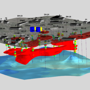
![]() The MOVE suite developed by Midland Valley is the most complete structural modelling and analysis toolkit available. It provides best practice structural modelling with a whole digital environment for reducing risk and uncertainties in geological modelling.
The MOVE suite developed by Midland Valley is the most complete structural modelling and analysis toolkit available. It provides best practice structural modelling with a whole digital environment for reducing risk and uncertainties in geological modelling.
The MOVE suite includes data integration and interpretation tools, cross-section construction, 3D model building, kinematic restoration and validation, geomechanical modelling, fracture modelling, fault response modelling, and fault and stress analysis.
Midland Valley Move 2018 is a powerful data integration and cross-sectional construction application with 3D modelling features. It comes with a set of professional tools and reliable data integration features. It is a robust application that includes professional tools for 2D and 3D motor modelling as well as geomechanical modelling. This powerful application supports error response and stress analysis for greater design control. Read more about the MOVE geological Software and access the tutorials for its applications.
-
Surfer Software
 After putting a lot of effort to collect your data, do not accept mediocre visualization. Make use of Surfer’s extensive modelling tools to present your data in the way it deserves while maintaining accuracy and precision.
Surfer can clearly communicate information about geology, hydrology, the environment, construction, and other topics. Surfer is a Microsoft Windows-based contouring and 3D surface mapping software program. Surfer software converts your data into outstanding contour, surface, wireframe, vector, image, shaded relief, and post maps quickly and easily. Using Surfer software tools, you can customize virtually every aspect of your maps to produce the exact presentation you want. It’s never been easier to create high-quality maps for geological reports and scientific publications. Learn more about the surfer software and its applications.
-
Rockworks
 RockWorks is an all-in-one software package for generating 2D and 3D maps, logs, cross-sections, geological models, general geology diagrams and volume reports. It is applied in environmental, geotechnical, mining, and petroleum industries.
It is the industry standard for surface and subsurface data visualization in the petroleum, environmental, geotechnical, and mining industries, with popular tools such as maps, logs, cross-sections, fence diagrams, solid models, and volume calculations. It provides various options for analyzing surface and subsurface data and accepts a wide range of data types, including stratigraphy, lithology, downhole geochemistry, geophysics, geotechnical measurements, colour intervals, fractures, and aquifer data.
Rockworks geological software can also analyze and visualize interval and point data like stratigraphy, lithology, quantitative data, colour intervals, fracture data, and hydrology and aquifer data. Geotechnical, environmental, mining, and petroleum industries use this software.
You can access more information about the Rockworks geological software on the company website.
-
QGIS
 QGIS is geographic information system (GIS) software that allows users to analyze and edit spatial data, as well as create and export graphical maps. QGIS supports raster and vector layers, with vector data stored as point, line, or polygon features. The software can georeference images and supports multiple raster image formats.
As compared to ArcGIS, QGIS geological software is open source and with unbeatable community support and tutorials.
-
GeoStudio Software
GeoStudio 2021 R2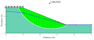 geological software gives you the ability to solve a wide range of new problems. SIGMA/W now provides faster performance and more robust convergence for nonlinear problems and new constitutive models, In Situ field stress definition, and Strength Reduction Stability. Increased interoperability with CAD software and Leapfrog Works are among the enhancements to the 3D products.
SLOPE/W is the industry standard for slope stability software for soil and rock slopes. SLOPE/W can analyze simple and complex problems for a wide range of slip surface shapes, pore-water pressure conditions, soil properties, and loading conditions. With such a wide range of features, SLOPE/W can be used to analyze almost any slope stability problem in geotechnical, civil, and mining engineering projects. Check out its brochure for more details.
-
XLSTAT
 XLSAT is not a geological software but is a fantastic all-inclusive statistical add-in for Microsoft Excel. Simple and user-friendly. Solutions tailored to specific business requirements. Available in a variety of languages. Automated and adaptable. Intuitive is a word to describe someone intuitive. It is reasonably priced with three license categories; Corporate, academic, and student types.
-
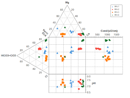
Aquachem
 Global Mapper is cutting-edge GIS software that offers both novice and experienced geospatial professionals a comprehensive set of spatial data processing tools and access to an unrivalled range of data formats. The intuitive user interface and logical layout of Global Mapper geological software help to smooth the learning curve that ensures simplicity and flexibility of users. Organizations of all sizes quickly see a significant return on investment due to efficient data processing, precise map creation, and optimized spatial data management. Global Mapper, which was created for both GIS professionals and map enthusiasts, has all of the functionality you need in GIS software. Its benefits include;
- Effortless and flexible data importing and exporting
- Automatic geochemical calculations of water type, the sum of anions, the sum of cations, ion balance, TDS, hardness, and other parameters
- Excessive water quality reports for multiple water quality standards
- Automated ready-made reports
-
Global Mapper
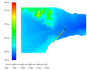 Global Mapper is cutting-edge GIS software that offers both novice and experienced geospatial professionals a comprehensive set of spatial data processing tools and access to an unrivalled range of data formats. The intuitive user interface and logical layout of Global Mapper geological software help to smooth the learning curve that ensures simplicity and flexibility of users. Organizations of all sizes quickly see a significant return on investment due to efficient data processing, precise map creation, and optimized spatial data management. Global Mapper, which was created for both GIS professionals and map enthusiasts, has all of the functionality you need in GIS software.
-
Google Earth
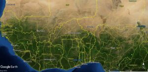
Google Earth is a geological software and an amazing program used by everyone in all sectors. It maps the Earth using superimposing satellite images, aerial photography, and GIS data onto a 3D globe, allowing users to view cities and landscapes from different perspectives. Users can travel around the world by entering addresses and coordinates or by using a keyboard or mouse. Make maps and stories. It is excellent for making maps, adding photos and videos, customizing your view, and sharing and collaborating with others using the creation tools. Google Earth is the world’s most detailed globe.
![]()
Get in touch with us for any data and visualization needs.
1 Reply to “Must have geological software by geoscientists”
Comments are closed.